Living in or visiting Whangamata means enjoying stunning beaches and a vibrant community. However, our beautiful coastal location also makes us susceptible to severe weather and flooding. Being informed and prepared is key to staying safe. This guide covers everything you need to know about Whangamata flooding, from risk areas and history to real-time warnings and emergency steps.
n
About Whangamata Flooding & Weather Warnings: What to Know
n
Understanding Whangamata’s Flood Risk Areas
Flooding in Whangamata is typically caused by a combination of heavy rainfall, high tides, and storm surges. The primary risk areas are low-lying zones where water naturally accumulates.
- The Estuary and Low-Lying Peninsula: Properties and roads around the Whangamata estuary are highly vulnerable, especially during king tides coupled with heavy rain.
- Otahu River Corridor: Areas adjacent to the Otahu River can experience rapid river flooding during periods of intense rainfall upstream.
- Other Low-Lying Streets: Several residential streets with inadequate drainage can experience localised surface flooding during extreme downpours.
A History of Flooding & The Impact of Cyclone Gabrielle
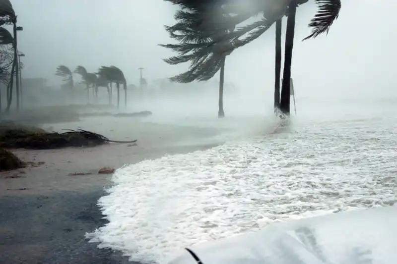
Whangamata has experienced significant flood events in the past. Major storms can isolate the town, cause property damage, and disrupt essential services. Most recently, Cyclone Gabrielle in February 2023 served as a stark reminder of our vulnerability. While not the most severely hit area, Whangamata still faced powerful winds, intense rainfall, and associated flooding, highlighting the critical importance of preparedness for all Whangamata storms.
How to Check for Official Warnings
Don’t rely on social media alone. For authoritative information, use these official sources:
- MetService: Your primary source for all weather forecasts, heavy rain warnings, and severe wind warnings for the Coromandel region. Check their website or app regularly.
- Thames-Coromandel District Council (TCDC) Civil Defence: TCDC issues local states of emergency, specific flood warnings, and crucial updates on road closures during floods. Follow them on Facebook and check their website.
- Waikato Regional Council: Provides river level and rainfall data which can indicate developing flood risks.
- NZTA Journey Planner: For real-time status of State Highway 25 and other key roads.
What to Do During a Flood Event in Whangamata
If a severe weather warning is issued and flooding is imminent or occurring:
- Stay Informed: Continuously monitor official channels (MetService, TCDC).
- Prepare to Evacuate: If you are in a low-lying area, be ready to move to higher ground. Have your “grab bag” ready.
- Never Walk or Drive Through Floodwater: Just 15cm of fast-flowing water can knock you over, and 30cm can float a car. It is often deeper and faster than it looks and may be contaminated.
- Check on Neighbours: Ensure elderly or vulnerable neighbours are aware and have a plan.
- Secure Property: Move valuables and electrical items to higher levels if safe to do so.
Road Closures & State Highway 25 Vulnerability
During heavy rain, several key access routes in and out of Whangamata can be compromised. The Kopu-Hikuai Road (SH25A) is historically prone to major slips. SH25 itself, both north and south, can be closed by flooding, slips, or fallen trees, potentially isolating the town. Always check the NZTA Journey Planner before travelling. Assume that if there’s a severe warning, roads may close with little notice.
Emergency Contacts & Flood Map Information
In a life-threatening emergency, dial 111.
For urgent flooding issues that threaten property, contact TCDC on 07 868 0200.
For the latest Whangamata flood map information and detailed hazard maps, visit the Waikato Regional Council website. These maps show historical flood extents and modelled inundation areas, which are crucial for understanding your property’s risk.
Building Resilience for the Future
As a community, we can build resilience. This includes supporting local flood mitigation projects, ensuring properties are built or retrofitted to better withstand flooding, and having a household emergency plan with supplies for at least three days. Knowing your risk, having a plan, and helping your neighbours makes Whangamata stronger.
Whangamata Flooding FAQ
How do I know if Whangamata is flooded right now?
Check the live cameras (if available) on the TCDC website, follow TCDC Civil Defence on Facebook for real-time updates, and check the MetService rain radar. Searching “whangamata flooding today” often brings up the latest social media posts, but always verify with official sources.
Is Whangamata prone to flooding?
Yes, parts of Whangamata are prone to flooding, particularly low-lying areas near the estuary and the Otahu River. Historical events and flood maps confirm this risk.
What was the impact of Cyclone Gabrielle in Whangamata?
Cyclone Gabrielle caused significant storm damage, including flooding, wind damage, power outages, and road closures due to slips and fallen trees. It underscored the town’s exposure to extreme weather.
Where can I find a Whangamata flood map?
Detailed flood hazard maps are available on the Waikato Regional Council’s website. These are the most authoritative source for understanding flood plains and historical flood risk in the area.
What roads close first when Whangamata floods?
Low-lying roads around the estuary, such as parts of Harbour Road, are often the first to be affected by surface flooding. Access routes like SH25 north and south can also close due to slips and flooding at key pinch points.
Stay safe, Whangamata. By knowing the risks, staying informed, and looking out for each other, we can weather any storm.