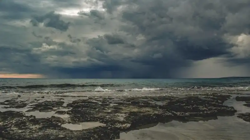
Whangamata is bracing for a volatile summer season as a series of low-pressure systems sweep across the Coromandel Peninsula, bringing heavy rain, gusty winds, and a renewed threat of coastal erosion along the township’s most vulnerable stretches. Local authorities and residents are closely monitoring conditions, particularly around the harbour entrance and the iconic surf beach, where sand levels have dropped dramatically over the past three months.
“We haven’t seen this kind of sustained easterly swell since the winter of 2018,” said Margaret Tanner, a long-time resident of Beach Road who has lived in Whangamata for 42 years. “The dunes are taking a real hammering. Some mornings I walk down to the boat ramp and the beach looks like a completely different place.”
Seasonal shifts and wild weather patterns
According to data from the Thames-Coromandel District Council (TCDC), Whangamata recorded 187 millimetres of rain in November alone — nearly 40 percent above the long-term average for that month. December has so far been unsettled, with a series of cold fronts bringing unseasonably cool temperatures and strong southwesterly winds that have made conditions hazardous for boaties and swimmers alike.
Local meteorologist Dr. James Whitford, who runs a private weather station from his home on Port Road, described the pattern as “a classic La Niña hangover with a twist.”
“We’re seeing a lot of instability in the Tasman Sea,” Dr. Whitford explained. “That means more frequent rain events and stronger onshore winds than we’d normally expect in early summer. It’s not unprecedented, but it is concerning for a coastal community that relies so heavily on its beaches and harbour for tourism and recreation.”
Coastal erosion: a growing concern
The most visible impact has been along the Whangamata surf beach, where the high tide line has crept inland by an estimated 12 metres since October. The erosion has exposed tree roots, undercut walkways, and forced TCDC to close sections of the beach access near the southern end of Beach Road.
Council spokesperson Fiona O’Leary confirmed that a team of coastal engineers visited the site last week to assess the damage. “We are particularly concerned about the area opposite Williamson Park,” Ms. O’Leary said. “The dune system there is fragile, and we’ve lost a significant volume of sand. We are working with Waikato Regional Council to model future scenarios and determine whether a managed retreat or a soft-engineering solution is appropriate.”
At the harbour entrance, the sand spit that protects the inner channel has narrowed considerably. Local fishing charter operator Ben Hauraki of “Hauraki Charters” said the changing shape of the harbour mouth is making navigation tricky. “We’ve had to adjust our departure times around the tides much more carefully than in previous years,” Mr. Hauraki said. “If this keeps up, we could see the channel shoaling in ways that affect both recreational and commercial users.”
Conservation news: DOC steps up protection
Amid the weather concerns, the Department of Conservation (DOC) has announced a new predator control initiative in the Whangamata area, focusing on the forests surrounding the Wentworth Valley and the Whenuakite Reserve. The programme, funded by a $120,000 grant from the Ministry for the Environment, aims to reduce rat and stoat populations to protect native bird species, including the North Island kōkako and the toutouwai (robin).
DOC ranger Sarah Mitchell, based at the Whangamata field office, said the timing is critical. “Spring and early summer are the peak breeding seasons for many of our native birds,” Ms. Mitchell explained. “With the wet weather we’ve been having, predator numbers are higher than usual because food sources are more abundant. We’re deploying 200 new self-resetting traps along the ridges above the harbour, and we’re asking the community to report any sightings of feral cats or stoats in the area.”
Volunteer groups, including the Whangamata Harbour Care Trust, have already begun weekly monitoring walks. Trust chairperson David Chen said the community response has been heartening. “People really care about this place. We’ve got 30 regular volunteers now, and we’re always looking for more. The bush around the harbour is a treasure, and we want to keep it that way.”
Marine environment: a mixed picture
The marine conditions around Whangamata are showing signs of stress, according to a recent water quality report from Waikato Regional Council. Sampling sites near the Whangamata Harbour boat ramp and the mouth of the Wentworth River recorded elevated levels of sediment and nutrients following the heavy November rains.
“The runoff from farmland and forestry operations upstream is a persistent issue,” said Dr. Emily Rangi, a marine biologist with the University of Waikato who has studied the Coromandel coastline for a decade. “When we get these intense rain events, the sediment plume can extend several kilometres out to sea, smothering seagrass beds and affecting shellfish populations.”
However, there is good news for recreational fishers: the snapper fishery in the outer harbour and along the coast appears to be healthy, with several recent catches reported of fish over 60 centimetres. Local fishing club president Kevin O’Neill said the cooler water temperatures seem to be keeping the fish active. “The fishing has been surprisingly good for this time of year. You just have to pick your days — the wind has been the biggest challenge.”
What’s next for Whangamata
Looking ahead, TCDC has scheduled a public meeting for 10 January at the Whangamata Community Centre to discuss the coastal erosion issue and present preliminary findings from the engineering assessment. Meanwhile, DOC will hold a volunteer training session on 15 January at the Williamson Park pavilion for anyone interested in joining the predator control programme.
For residents and visitors alike, the message is one of vigilance and community spirit. As Margaret Tanner put it: “Whangamata has weathered plenty of storms before. We just need to work together — council, DOC, and locals — to make sure our little slice of paradise stays beautiful for the next generation.”
Frequently Asked Questions
Is it safe to swim at Whangamata Beach right now?
Swimming is generally safe, but be aware of strong rips, especially after heavy rain or during easterly swells. Check the Safeswim website for real-time water quality updates at monitored beaches. The council advises avoiding swimming near stormwater outlets for 48 hours after significant rainfall.
What is being done to stop the coastal erosion?
The Thames-Coromandel District Council, in partnership with Waikato Regional Council, is conducting a coastal hazard assessment. Options being considered include dune restoration with native planting, sand nourishment, and possible managed retreat in the most vulnerable areas. A public meeting is scheduled for 10 January to discuss findings.
How can I get involved in conservation efforts?
The Department of Conservation runs a volunteer predator control programme in the Whangamata area. You can attend the training session on 15 January at Williamson Park pavilion, or contact the Whangamata DOC field office directly. The Whangamata Harbour Care Trust also welcomes new volunteers for regular bush and beach clean-ups.