About the Patiki Reserve Walkway
The Patiki Reserve track is one of the Coromandel’s hidden gems — a clifftop coastal walkway connecting Whangamata and Onemana along a spectacular stretch of coastline. The track follows the edge of steep coastal cliffs through regenerating native bush, pohutukawa groves and open headlands with panoramic views across the Pacific. It is roughly 4 kilometres one way and takes about an hour at a steady pace, though you will want to stop frequently for the views.
The track can be walked in either direction. Most people start from the Whangamata (southern) end where the track begins at the end of Doris Place, off Hetherington Road. The Onemana end starts near the top of Onemana Drive. If you have two cars, you can leave one at each end. Otherwise, it is an out-and-back walk of about two hours from whichever end you choose.
Trailheads
Whangamata Trailhead (Hetherington Road End)
The southern starting point for the Patiki Reserve walkway is at the end of Doris Place, off Hetherington Road in northern Whangamata. A small gravel area provides parking for a handful of cars — arrive early in summer as spaces fill quickly. The track entrance is clearly signposted with a DOC-style information board showing the route and estimated walking times. The first section climbs steadily through dense pohutukawa and kanuka before opening onto the clifftops.
Onemana Trailhead (Onemana Drive)
The northern end of the Patiki Reserve track begins near the top of Onemana Drive as you enter the settlement from State Highway 25. Look for the track signpost on the left-hand side of the road. Parking is available on the wide grass verge. Starting from this end, the track descends gradually along the coast before climbing and dipping through a series of headlands on the way to Whangamata. This end is slightly less steep to begin with, making it a good choice if you prefer to ease into the walk.
The Walk
Patiki Reserve Coastal Walkway
The track winds along the cliff edge through a mix of coastal pohutukawa forest, kanuka scrub and open grassy headlands. The path is well-formed but narrow in places, with some uneven surfaces and exposed tree roots. Several sections follow the cliff edge with steep drop-offs — keep children close and dogs on a lead. The track undulates through a series of small valleys and ridgelines, with short climbs and descents throughout. After rain, the clay sections can be slippery, so sturdy footwear with good grip is essential.
Along the way you will pass through groves of ancient pohutukawa that cling to the cliff face — these are spectacular in December when they burst into crimson flower. The native bush is home to tui, fantails, grey warblers and kereru (wood pigeons). Listen for the distinctive song of the tui in the canopy and watch for fantails flitting along the track ahead of you.
Lookout Points
Clifftop Lookout Points
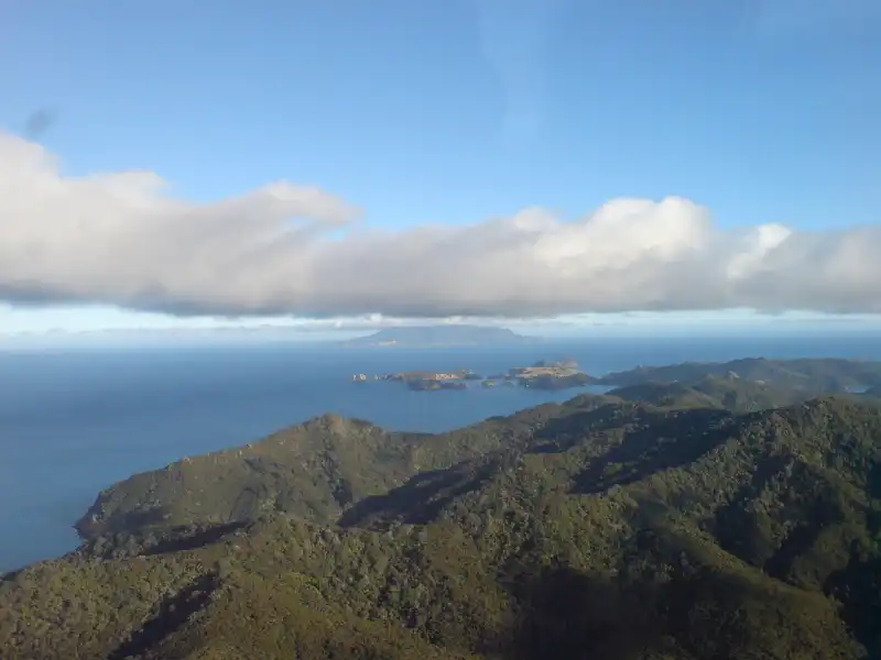
The Patiki Reserve track passes several natural lookout points where the bush opens to reveal sweeping coastal panoramas. The best viewpoints are roughly midway along the track, where the cliffs are highest and the views extend in both directions along the coast. From these vantage points you can see south to Whangamata Beach and the harbour entrance, north to Onemana Beach and its rocky headlands, and out to sea towards Hauturu (Clark Island) and beyond. On clear days Mayor Island (Tuhua) is visible on the horizon.
These lookout points are natural clearings — there are no built platforms or safety barriers, so stay well back from the edge. They are excellent spots for photography, particularly in the golden light of early morning or late afternoon. Between June and October, keep your eyes on the ocean — humpback whales occasionally pass along this stretch of coast during their annual migration.
What to Bring
- Sturdy footwear — the track has uneven surfaces, tree roots and clay sections that become slippery when wet. Do not attempt it in jandals
- Water — there is no water source on the track. Carry at least 500ml per person
- Sun protection — much of the track is exposed to the sun, especially the headland sections
- Insect repellent — sandflies can be persistent in sheltered sections, particularly on still days
- Camera — the coastal views are among the best in the Coromandel
Tips for the Walk
- The track is best walked in the cooler parts of the day — early morning or late afternoon. The midday sun on exposed headlands can be intense in summer
- After heavy rain, wait a day or two for the track to dry. The clay sections become very slippery and some parts may be muddy
- Dogs are permitted but must be on a lead at all times to protect native birdlife
- If doing an out-and-back walk, the Whangamata end offers better views on the return leg with the sun behind you
- Combine with a visit to Onemana Beach for a swim at the other end — Onemana has a small general store for refreshments in summer
Other Walks Nearby
- Wentworth Valley and Waterfall — a 3-hour return walk through native bush to a stunning 50-metre waterfall, 10 minutes’ drive from Whangamata
- Island View Reserve — a short 15-minute walk with panoramic views of the harbour and offshore islands
- Luck at Last Mine Track — a historic gold mining track in the Wentworth Valley, about 2 hours return