Islands Off Whangamata
Several islands and rocky outcrops are scattered across the waters off Whangamata, visible from the beach and harbour on any clear day. The most prominent is Hauturu (Clark Island), sitting in the harbour mouth like a sentinel guarding the entrance. These islands are ecologically significant — many serve as predator-free refuges for seabirds and native plants, and they hold deep cultural importance for Ngati Hei and Ngati Maru, the local iwi. While public access to most is restricted, they form a dramatic part of the Whangamata seascape and there are excellent ways to appreciate them from shore and water.
Hauturu (Clark Island)
Hauturu (Clark Island)
Hauturu, commonly known as Clark Island, is the prominent bush-covered island sitting at the mouth of Whangamata Harbour, roughly 800 metres offshore. The island is approximately 12 hectares and rises steeply from the water to a bush-clad summit. It is a DOC-administered wildlife refuge and is culturally significant as a waahi tapu (sacred place) for local iwi. The island is predator-free and supports breeding populations of grey-faced petrels, little blue penguins and various other seabirds. Native coastal bush — including large pohutukawa, karo and coastal karaka — covers the island.
Landing on Hauturu is not permitted without DOC and iwi approval. However, you can kayak or boat around the island (keeping a respectful distance from nesting areas), and it is a popular landmark for recreational fishers working the harbour entrance. The island is best viewed from Island View Reserve or from the harbour side of the sandspit.
Other Harbour Islands & Rocks
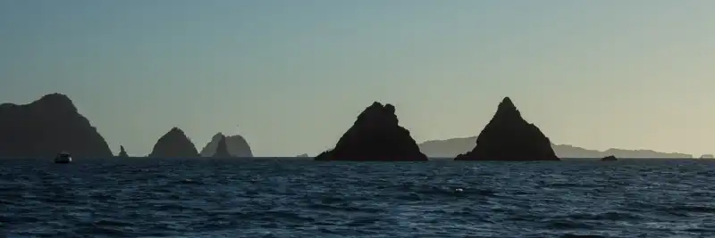
Whangamata Harbour Islands & Rocks
Beyond Hauturu, several smaller rocky islets and outcrops dot the harbour entrance and near-shore waters. These include Rakaumangamanga and other unnamed rocky pinnacles that are exposed at low tide. While small and rocky, these outcrops are important haul-out spots for New Zealand fur seals (increasingly common along the Coromandel coast) and roosting sites for shags, oystercatchers and red-billed gulls.
The harbour entrance itself is a dynamic environment — strong tidal currents flow between Hauturu and the sandspit, creating turbulent water that attracts fish and, in turn, seabirds. On calm days you can often see flocks of Australasian gannets diving just outside the harbour mouth, and occasionally dolphins ride the tidal flow through the entrance channel.
Further offshore, the rocky reef systems extending from the headlands provide excellent snorkelling and diving territory in calm conditions. These reefs are home to crayfish, large snapper, kingfish and a variety of reef fish.
Best Viewing Points from Shore
Island View Reserve
Island View Reserve is the best land-based vantage point for viewing Hauturu and the harbour islands. This small, elevated reserve sits on the headland between the harbour and the open coast, reached by a short 10 to 15 minute walk from the car park at the end of Island View Road (off Moana Anu Anu Avenue). A bench seat at the top provides a panoramic view directly across to Hauturu, with the harbour entrance, sandspit, and open ocean all visible. On clear days you can see Slipper Island, the Aldermen Islands, and Mayor Island on the horizon.
This is an excellent spot for photography — particularly at sunrise when the islands are silhouetted against the eastern sky, or at sunset when the pohutukawa-clad slopes of Hauturu glow golden. Bring binoculars to spot seabirds around the island and, in winter, watch for whale blows on the horizon.
Kayaking Around the Islands
Kayaking is the best way to get close to Hauturu and the harbour islands without needing a powered boat. Several options are available:
- Guided kayak tours — operators such as Pedal and Paddle run guided trips that paddle around Hauturu and through the harbour, with commentary on the ecology and history of the islands. These tours typically depart from the harbour side and take 2 to 3 hours
- Self-guided kayaking — if you have your own kayak or hire one, you can paddle from the harbour boat ramp around Hauturu. Stay at least 20 metres offshore from the island to avoid disturbing nesting seabirds. Check tide times carefully — the harbour entrance currents can be dangerously strong on a running tide
- Combine with Whenuakura (Donut Island) — many kayak tours combine a loop around Hauturu with a visit to Donut Island, making for a spectacular half-day on the water
Wildlife to Look For
- Grey-faced petrels — these seabirds nest in burrows on Hauturu and can be seen flying at dusk during breeding season (April to November)
- Little blue penguins — New Zealand’s smallest penguin breeds on the islands and can occasionally be spotted in the harbour at dawn and dusk
- Australasian gannets — often seen diving spectacularly into the water near the harbour entrance
- New Zealand fur seals — increasingly common, often hauled out on rocky outcrops around the harbour
- Dolphins — common and bottlenose dolphins are frequently seen in the harbour and along the coast
- Orca — occasional visitors, usually hunting stingrays in the harbour shallows. If you are lucky enough to see them, maintain at least 50 metres distance
Respecting These Places
The islands off Whangamata are taonga (treasures) — ecologically and culturally. If you are out on the water, respect the following:
- Do not attempt to land on Hauturu or any island marked as a wildlife refuge
- Keep at least 20 metres from island shorelines to avoid disturbing nesting birds
- Do not feed or approach marine mammals — it is illegal under the Marine Mammals Protection Act
- Observe any rahui (temporary closures) that may be in place — these are signposted at boat ramps and beaches
- Take all rubbish with you and do not discard fishing line or tackle in the water